预约演示
更新于:2026-02-03
International CSRC Investment Holdings Co. Ltd.
更新于:2026-02-03
概览
关联
100 项与 中国合成橡胶股份有限公司 相关的临床结果
登录后查看更多信息
0 项与 中国合成橡胶股份有限公司 相关的专利(医药)
登录后查看更多信息
18
项与 中国合成橡胶股份有限公司 相关的新闻(医药)2025-04-05
据统计,2024年国内合成生物制造相关的融资次数超过60起。合成生物已然成为国内最热门的投资领域之一。2025年延续了这股热潮。据不完全统计,2025年第一季度,就有十数家合成生物学企业获得了高额融资。企业:南京益唯森生物科技有限责任公司融资轮次:Pre-A融资金额:数千万元益唯森是合成生物学技术企业,专注于研究生产功能性天然化合物,通过生物转化和生物发酵生产功效性天然产物制品,致力于西北地区特色植物资源的保护和可持续开发利用,为市场提供功效性原料和特色功效食品。Pre-A轮的数千万元融资将着重用于益唯森在青海的生物制造工厂建设以及新原料认证,全力打造白刺及极端环境植物资源综合开发生物制造工厂,专注专精特新产品研发和生产。企业:南京纽邦生物(NNB Nutrition)融资轮次:B融资金额:数千万元纽邦生物成立于2015年,主要面向全球市场提供创新型膳食营养补充剂原料、半成品等产品,曾服务的海外内知名企业包括GNC、雀巢、亚马逊、华熙生物等。本轮融资由华熙元祐基金投资,募集资金将主要用于公司新产品研发、生产及市场拓展等。企业:格瑞农生物融资轮次:Pre-A融资金额:数千万元格瑞农生物是一家噬菌体生物制造产业平台公司,运用噬菌体技术专注于研发针对植物细菌性疾病的相关产品。格瑞农以创新为驱动,为植物保健提供了新的生物防治方案,减少化学农药使用,降低环境污染,助力农业可持续发展。公司于2024年成功产业化对青枯病、溃疡病等植物主要病害的“小青宁、溃疡宁”等噬菌体系列产品,植保产品于今年正式面向市场。本轮融资主要用于加速噬菌体多应用场景产品创新、证书申报等工作。企业:深圳粒影生物科技有限公司融资轮次:A融资金额:近亿元粒影生物成立于2022年4月,致力于成为蛋白结构设计领域的硬科技先锋。粒影生物通过结合结构生物学和人工智能计算设计,对蛋白质进行改造和优化,以满足不同行业客户的定制化需求。服务覆盖生物医药、化工酶改造、食品原料、医疗器械及日化等多个领域,提供从设计到小试、GMP中试,再到量产突破的蛋白产品解决方案。新一轮融资主要用于三螺旋胶原蛋白产能扩展、注册报证及相关产品的市场推广工作。随着本轮融资完成,粒影生物开发出一系列具备三螺旋结构的胶原蛋白将从中试走向量产,从原料变为产品,从抗皱修护到头皮头发护理/防脱发等产品。企业:蘑米生物融资轮次:A融资金额:数千万元蘑米生物成立于2022年,致力于从国内庞大的真菌生物多样性资源中发现、筛选及改造得到可高效生产目标蛋白的菌株,以更低成本、更可持续的方式规模化生产真菌蛋白及健康食品。新一轮的融资资金将用于核心技术创新、产品研发、工厂建设、市场拓展、团队扩建等用途,以全面增强公司的竞争优势。企业:南京食气生化科技有限公司融资轮次:Pre-A+融资金额:未披露食气生化成立于2023年1月,致力于碳源利用方式变革,以负碳生物制造驱动煤化工、钢铁等产业升级,服务粮食安全和“双碳”目标。公司拥有领先的食气梭菌改造技术积累与丰富的产品及放大工艺开发经验,已开发出全球唯一可解锁广阔下游产物空间的独家特种梭菌,可转化富含CO、CO2的工业尾气、生物质气生产大宗化学品、可持续航煤(SAF)和饲料蛋白,具有显著的成本和降碳优势。在2025年1月的Pre-A+轮融资之前,食气生化在2024年2和8月分别完成了天使轮和Pre-A轮融资。企业:广东菁萃生物科技有限公司融资轮次:天使+融资金额:千万元菁萃生物成立于2018年8月,以农林废弃物为基础原料,采用自主研发的水系分离技术提取生物表面活性剂(皂苷),以“让纯天然绿色表面活性剂成为常规表活”为目标,专注于生物表面活性剂的研发、生产和销售。本次融资募集的资金将主要用于扩大产能、加强销售和建设团队等。企业:南京森奇新材料科技有限公司融资轮次:B融资金额:数千万元森奇新材成立于2019年7月,是一家生物基新材料研发商,专注于新材料服务领域,主要从事生物基新材料、特种薄膜和高功能包装研发业务。在2025年2月的B轮融资之前,森奇新材于2024年7月完成由皓沣资本与美天晟创投共同投资的数千万元A轮融资。企业:深圳瑞德林生物技术有限公司融资轮次:C融资金额:超5亿元瑞德林生物成立于2017年,是国内最早一批成立的合成生物学企业之一,致力于将固定化酶催化技术应用于多肽、多糖、非天然氨基酸等领域产品的开发,所开发的产品广泛应用于医药、保健品、化妆品、食品、饲料等行业。本轮融资是瑞德林生物完成的第六轮融资。也是2025年第一季度金额最高的一笔融资。企业:中科国生(杭州)科技有限公司融资轮次:A+融资金额:2亿元中科国生成立于2021年7月30日,在生物质催化转化和呋喃类材料领域拥有近20年的研究基础及产业化经验。公司通过自研的“SMART”催化体系+“短流程”生产方案,实现了HMF及FDCA的双连续化工业级生产,大幅降低产品成本,并在浙江丽水和江苏泰兴设有百吨级和万吨级工厂。本轮融资资金将重点用于位于江苏泰兴的万吨级产能建设,加速产能扩张以进一步降低成本。企业:北京藻辰生物科技有限公司融资轮次:天使融资金额:千万元藻辰生物专注于采用微藻生物合成技术制造创新蛋白和营养功能性成分,致力成为微藻产业从“农业化”向“工业化”转变的先行者,为国家构建多元化食物供给体系和推动营养健康产业发展提供解决方案。本轮融资由泉华生命领投,资金将用于微藻合成生物学衍生品研发平台、中试生产平台建设。企业:上海依诺基科生物技术有限公司融资轮次:A融资金额:1.5亿元依诺基科成立于2022年9月,是一家致力于绿色生物产品研发和生产的合成生物学公司,产品覆盖天然香料、营养健康、生物医药等领域。目前,依诺基科已经完成3轮融资,累计融资额近3亿元人民币,包括2023年1月完成的5000万元的天使轮融资;2023年11月完成的Pre-A轮融资。企业:浙江益思特生物科技有限公司融资轮次:A融资金额:数千万元益思特生物成立于2018年,是一家以合成生物学为核心的技术型企业。公司依托产学研合作,构建了以酶工程、代谢工程为核心的发酵技术平台和产品开发平台,涵盖了菌种开发、酶法工艺应用以及产品开发全链条技术。公司产品可应用于食品、功能食品原料、医药原料领域。企业:浙江馨海生物科技有限公司融资轮次:战略投资融资金额:未披露馨海生物成立于2015年,是一家具备完整创新研发能力的合成生物学平台公司,专业从事生物酶制剂、手性化学品、动物营养品等研发、生产、销售。2025年3月14日,中化资本创投旗下山东省新动能中化绿色基金(中化绿色基金)完成了对国内合成生物学先进企业馨海生物的战略投资,这是中化资本创投围绕中国中化生命科学领域,积极布局未来产业的又一次落子。企业:江苏仅三生物科技有限公司融资轮次:Pre-A融资金额:亿元仅三生物成立于2021年,是全球抗氧化活性原料麦角硫因领域的头部供应商,仅三生物依托合成生物学技术突破天然提取的效率和成本瓶颈,瞄准千亿级抗衰市场,加速抢占功能护肤与精准营养赛道先机,并探索其在眼部健康、睡眠、代谢疾病等领域的应用场景。
微生物疗法
2025-03-30
·海正药业
3月30日,2025第三届SBC合成生物学产业博览会(SBC 2025)在南京开幕。本届博览会以“合成新势、合成新知、合成新质”为主题,百余家头部企业及多位院士专家,通过六大主题展区、项目路演及产品市集等活动,集中展示了合成生物学技术创新与产业融合成果。海正药业首次参展,全面呈现了公司在合成生物领域的深厚积淀与产业化能力,与行业伙伴共探生物制造新未来。海正药业高级副总裁兼合成生物学产业创新中心总经理金红顺率团队参展。博览会上,海正展台重点展示了公司覆盖基因编辑、菌种构建、工艺放大、规模化生产的全链条技术体系,吸引了美妆、食品、农业等领域的众多企业代表驻足交流。金红顺高级副总裁说:“从实验室到工厂的跨越是合成生物学的关键挑战。作为国内合成生物学产业化先行者,海正药业将合成生物技术与国际化质量体系深度融合,拥有从技术研发到产业落地的深厚实力。”展会期间,海正药业研发中心副总经理兼创新药研究院院长周厚江受邀参加大会论坛,与行业专家就合成生物学技术转化路径展开深度探讨,分享了海正在工艺优化与产业化落地的实践经验。展望未来,金红顺高级副总裁表示,技术只有落地才能创造价值。海正将坚持“以产业需求为导向”,与上下游伙伴协同创新,推动合成生物技术从实验室走向市场。我们相信,通过持续的技术积累和开放合作,海正能为行业创造更多价值,为合作伙伴提供稳定、高效的生物制造解决方案,助力生物制造产业向绿色低碳转型。SBC 2025展览会将于3月31日闭幕,我们期待在海正药业展台与您共话合作,共创未来。
高管变更引进/卖出
2025-03-04
·赛柏蓝
作者 | 凯西 颜色
编辑 | 遥望
北大医药再次迎来高管变动,上任一年左右的董事长齐子鑫宣布辞职。
01
北大医药董事长辞职
此前业绩有所回温
3月4日,北大医药发布公告称,董事长齐子鑫因个人原因辞去董事、董事长职务,同时辞去董事会战略委员会主任委员、提名委员会委员、薪酬与考核委员会委员职务,且不再担任北大医药任何职务。
北大医药前身为西南合成制药股份有限公司,作为一家成立于1993年,1997年就在深交所上市的老牌药企,齐子鑫的辞职引发了市场对北大医药未来走向的猜测。
其实齐子鑫的辞职并非毫无征兆,今年1月,齐子鑫辞去方正控股执行董事一职,自称是希望投入更多时间用于方正信息产业的工作。
2025年以来,北大医药的监事徐伟钰、董事任甄华、董事张勇先后辞职。
齐子鑫自2024年2月29日接任北大医药董事长以来,仅任职一年左右。因恪守职责,推动北大医药高质量发展,齐子鑫的贡献受到肯定。
2024年前三季度,北大医药实现净利润1.3亿元,同比增长182.49%,创历史新高。
2024年上半年业绩上升,北大医药将其归因于两方面:
一是医药工业板块继续聚焦“抗感染类、镇痛类、精神类”领域,重点市场拓展成效显著,重点产品(注射用美罗培南、盐酸丁螺环酮片、注射用头孢噻肟钠、盐酸昂丹司琼片等)销量提升及降本增效带动盈利能力同比提升;二是医药流通板块,受益于其产业下游需求业务量的逐步增长,全资子公司北京北医医药的业务收入规模同比提升,故净利润同比有所增长。
北京北医医药,主要为北京大学国际医院提供医疗设备、药品、耗材等供应链服务。根据2022、2023年年报,在北大医药的营收构成中,药品流通占比超过60%。
然而北医医药与国际医院的合同将于2025年到期,在北大医药此前披露的公告中,这将使得其自2025年起可能面临年销售收入减少约9.10亿元,净利润损失约3666万元的风险。
此外,业绩暂时回温之下,北大医药的仿制药业务仍然面临调整。
2022年,北大医药实现营业收入20.77亿元,较去年同期下滑7.13%,北大医药称营业收入的下降主要受到带量采购、医保目录谈判等行业政策实施影响,好在通过降本增效,当年北大医药实现归母净利润5598.19万元,较上一年同期增长29.76%。
在2022年的年度报告中,北大医药称公司内部面临诸多挑战——重点品种头孢曲松钠受集采影响,销量价格大幅波动,大股东重整导致历史遗留的风险问题不断困扰公司的稳定发展。
注射用头孢曲松钠为第五批国采品种,米内网数据显示,2021年在中国公立医疗机构终端的销售额超过37亿元,2022年受国采执行影响下滑接近50%,2023及2024上半年有所回升。
02
失去“北大”名号
北大医药如何发展?
在2024年末,北大医药发布公告称,控股股东上层股权结构发生变动、实际控制人发生变更,“平安系”撤退。
新优势国际以1元的价格收购合成集团100%股权,同时支付3300万元,购买新方正控股和方正数码对合成集团及其下属公司的债权,完成“股权转让+债权转让”的捆绑式交易。
之后新优势国际成为北大医药第一大股东的控股股东,徐晰人成为北大医药实际控制人。
2009年起,北大医药的前身名称逐步变更,最终于2013年11月更名为“北大医药股份有限公司”,成为北大方正集团旗下核心医药资产平台。
此次北大医药的易主还伴随着公司名称的变更。交易完成后,北大医药将不得含有“北大”“北大医药”“北医”等字样,北大两字的明星光环可能不在。
3月1日,北大医药发布《第十一届董事会第六次会议决议公告》 ,提名徐晰人、杨力今为第十一届董事会非独立董事候选人。
在宣布控股股东上层股权结构发生变动、实际控制人发生变更后,今年2月,北大医药发布《关于控股股东上层股权结构调整的公告》。
控股股东上层股权结构调整后,北大医药股权控制关系如下:
作为一家老牌药企,北大医药的主要业务包括制剂研发、生产、销售及医药流通等,将“北大”融入其企业名称,一度对企业的品牌推广以及人才招揽助力不小。
失去“北大”字号后,新品牌的建立需要时间。
赛柏蓝注意到,北大医药近期发布公告称,出于促进公司产业链的发展,整合产业上下游资源,拓展国际化发展空间等目的,拟设立新的全资子公司——新优势(重庆)健康产业发展有限公司(暂定名),注册资本拟为3,000万元人民币(含)以内,经营范围包括药品生产、销售,普通货运、危险货物运输生产输液用袋、投资管理等。
从实控人生变到董事长离职,北大医药内部变动频繁,后续的资本故事将如何续写?
END
内容沟通:郑瑶(13810174402)
左下角「关注账号」,右下角「在看」,防止失联
高管变更带量采购财报
100 项与 中国合成橡胶股份有限公司 相关的药物交易
登录后查看更多信息
100 项与 中国合成橡胶股份有限公司 相关的转化医学
登录后查看更多信息
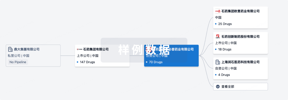
组织架构
使用我们的机构树数据加速您的研究。
登录
或
管线布局
2026年02月08日管线快照
无数据报导
登录后保持更新
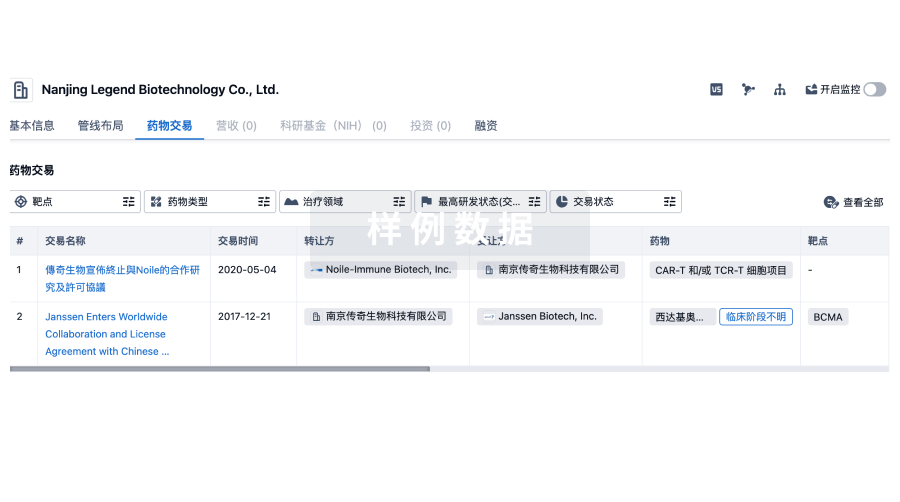
药物交易
使用我们的药物交易数据加速您的研究。
登录
或
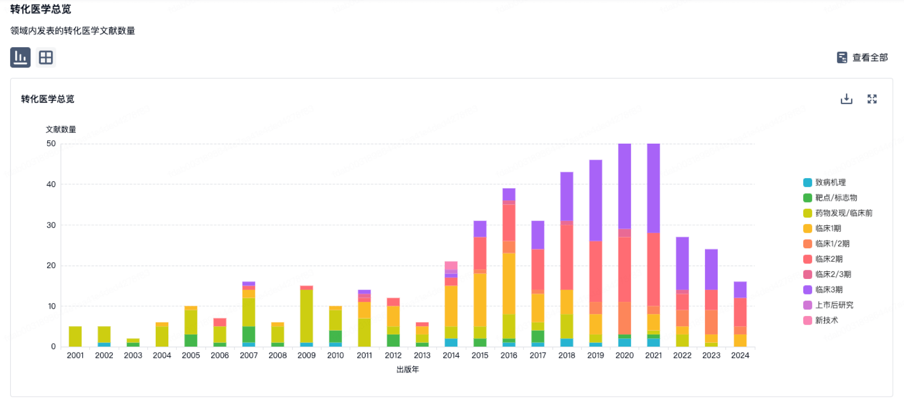
转化医学
使用我们的转化医学数据加速您的研究。
登录
或
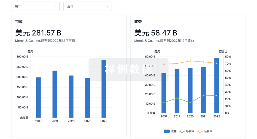
营收
使用 Synapse 探索超过 36 万个组织的财务状况。
登录
或
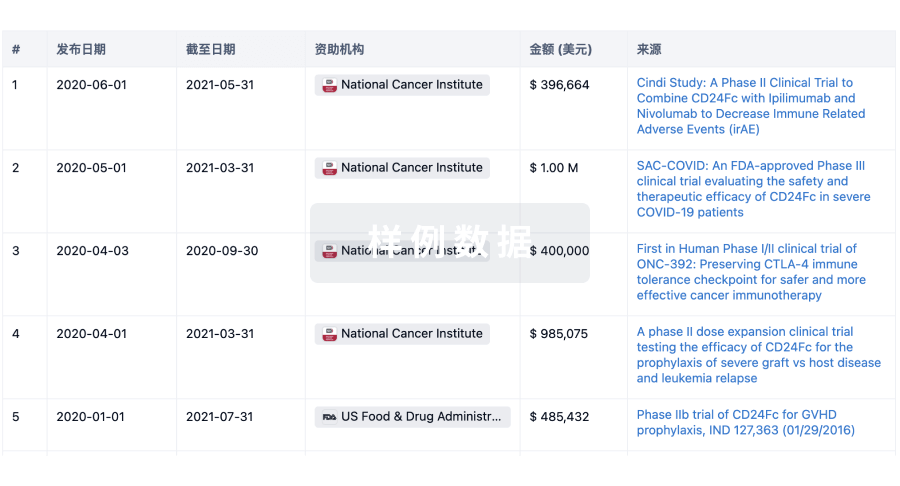
科研基金(NIH)
访问超过 200 万项资助和基金信息,以提升您的研究之旅。
登录
或
投资
深入了解从初创企业到成熟企业的最新公司投资动态。
登录
或
融资
发掘融资趋势以验证和推进您的投资机会。
登录
或
生物医药百科问答
全新生物医药AI Agent 覆盖科研全链路,让突破性发现快人一步
立即开始免费试用!
智慧芽新药情报库是智慧芽专为生命科学人士构建的基于AI的创新药情报平台,助您全方位提升您的研发与决策效率。
立即开始数据试用!
智慧芽新药库数据也通过智慧芽数据服务平台,以API或者数据包形式对外开放,助您更加充分利用智慧芽新药情报信息。
生物序列数据库
生物药研发创新
免费使用
化学结构数据库
小分子化药研发创新
免费使用